In the rapidly evolving world of drone technology, two terms frequently mentioned are RTK (Real-Time Kinematic) and PPK (Post-Processing Kinematic). These acronyms represent powerful tools that have revolutionized the accuracy and efficiency of drone applications in fields such as agriculture, surveying, and construction. Understanding these technologies is crucial for unlocking the full potential of drones in various industries.
What is RTK?
RTK stands for Real-Time Kinematic, a technique used to enhance the precision of satellite-based positioning systems like GPS. In traditional GPS, the accuracy can vary from several meters to tens of meters, which may not be sufficient for applications requiring centimeter-level precision. RTK solves this problem by providing highly accurate positioning down to centimeter-level in real-time.
The key to RTK’s accuracy lies in the use of a fixed base station and a rover. The base station, placed at a known location with precisely known coordinates, receives signals from satellites and calculates its position. The rover, mounted on the drone, also receives these signals. By comparing the signals from the base station with those from the rover, RTK can determine the rover’s position with exceptional accuracy. This correction data is transmitted in real-time to the drone, allowing it to adjust its position accordingly.
Applications in Agriculture
In agriculture, RTK has become invaluable for precision farming practices. Drones equipped with RTK can precisely map fields, monitor crop health, and apply fertilizers or pesticides with remarkable accuracy. This precision helps farmers optimize their resources, reduce waste, and increase crop yields. RTK-enabled drones can also create elevation models of fields, aiding in irrigation planning and land levelling.
Applications in Surveying
Surveying and mapping benefit greatly from RTK technology. Surveyors can use RTK-equipped drones to quickly and accurately collect data for topographic surveys, construction site monitoring, and infrastructure inspection. With centimeter-level accuracy, these drones can create detailed 3D models and maps, speeding up the surveying process while maintaining high precision.
Applications in Construction
Construction projects often require precise measurements and monitoring, which is where RTK-enabled drones shine. These drones can create accurate site maps, monitor construction progress, and even assist in tasks like volume calculations for earthworks. By providing real-time data with centimeter-level accuracy, RTK drones improve efficiency, reduce errors, and enhance safety on construction sites.
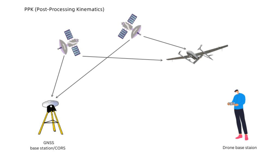
What is PPK?
PPK, or Post-Processing Kinematic, is another method for achieving high-precision positioning with drones. While RTK provides real-time corrections, PPK works slightly differently. Instead of receiving correction data in real-time, PPK stores raw GPS data during the flight. After the flight, this data is post-processed against a base station, similar to RTK’s base station, to calculate highly accurate positions.
One advantage of PPK is its independence from real-time communication links. Since it doesn’t rely on continuous corrections during the flight, PPK-enabled drones can operate in areas with poor or no communication signal. This makes PPK ideal for remote or challenging environments where RTK signals may be unreliable.
Enhancing Accuracy and Efficiency
Both RTK and PPK technologies significantly enhance the accuracy and efficiency of drone operations across various industries. By providing centimeter-level precision, these technologies enable:
Optimized Resource Use: Farmers can precisely apply fertilizers, pesticides, and water, reducing waste and maximizing crop yields.
Cost Savings: In construction and surveying, accurate drone data reduces the need for rework, saving time and money.
Improved Safety: With detailed site maps and real-time monitoring, construction sites can identify hazards early, improving safety protocols.
Quick Data Processing: The data collected by RTK and PPK drones can be rapidly processed into actionable insights, allowing for faster decision-making.
Conclusion
In the world of drone technology, RTK and PPK have unlocked a new era of precision and efficiency. Whether it’s optimizing agriculture practices, streamlining surveying operations, or improving construction site management, these technologies are reshaping industries. Understanding the capabilities of RTK and PPK is not just about knowing the buzzwords; it’s about harnessing the power of precise positioning to drive innovation and productivity forward. As these technologies continue to evolve, their impact on diverse fields will only grow, promising a future where precision is not just a goal but a standard in drone applications.